This story map provides a map-based interface to spatial data generated by the Historic Droughts, MaRIUS and DRY projects.
Tag: data
Data and tools for water supplies
Drought and woodlands
Woodland modelling undertaken by Dr Pam Berry and colleagues at the University of Oxford has explored in the impact of climate change on the distribution of key woodland species in Great Britain. The resultant datasets map changes in the drought vulnerability for 12 tree species and for two periods, the 2030s and the 2080s. Six categories of potential natural vegetation are also mapped for (i) the present, (ii) the 2030s and (iii) the 2080s. The modelling shows potential changes in leaf area, net primary productivity and net ecosystem productivity. A spatial explorer interface is in development, which allows users to explore these maps interactively, including zooming into their particular location, and allows the user to swipe between two periods for a given location. If you would like to be included as a beta tester for the explorer, please email nevil.quinn@uwe.ac.uk.
Drought impacts explorer
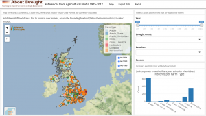
As part of the Historic Droughts project, researchers at Cranfield University developed an inventory of qualitative drought data related to UK agriculture based on an extensive review from two weekly farming magazines in the UK, Farmer’s Weekly and Farmers Guardian for the period 1975-2018. The resultant inventory contains over 2500 records with information on the start and end dates of the event and their location to characterise the temporal and spatial extents of the cited event, together with the text describing the driver, impact or response in relation to that event. The inventory is available to download as a csv file from the UK Data Service.
This dataset is also currently being translated in to a drought impacts explorer, which allows the user to view these records spatially and to search and save according to various criteria. If you would like to be involved in beta testing of the explorer please contact nevil.quinn@uwe.ac.uk. An early draft of the explorer is available online.